Hess Environmental, Inc. Ground Water Resources, Inc.
  • About Us
  • Underground Storage Tanks (UST), Phase II Phase 2, remediation Etc...
  • E1527-2021: Phase I Environmental Assessments and the New Standard
  • Ground Water
  • Law Firms
  • Large Ranches and Farms
  • Municipalities, Cities and Towns
  • News, Updates, Utah UST Deadlines
  • Demolitions
  • Drone Aerial Photography and Mapping
  • Soil Testing; Well Testing; Water Testing
  • Utah Earthquake, USTs and Drone Inspections
  • Aboveground Petroleum Storage Tanks (APST)
  • Household and Farm Hazardous Wastes
  • NEPA - USDA RD Rural Development
  • RCRA, SUPERFUND and RISK Based Closures
  • Contact Us
  • PAYMENTS
Call Hess Environmental, Inc. directly at (801) 361-9296
Picture

​Drone Aerial Photography and Mapping
FAA Certified Drone Pilots

Successful FAA Waivers 

Several Aerial Drone Platforms Available 


Droners.io Professional Aerial Photography Drone Pilot
Picture
Picture
At Hess Environmental, FAA licensed drone pilots and operate safely and legally. We capture aerial imagery and conduct mapping anywhere in the United States.  

We can capture detailed aerial imagery and conduct aerial mapping with our drones for a variety of industries: 
  • Real Estate Agents - Home Images and Video
  • Farm Managers (Crop Health, Cultivated Land Usage etc..)
  • City Managers
  • Construction Companies
  • Developers
  • Planned Projects or Projects Under Construction
  • Mining Companies
  • Or anyone needing updated aerial photographs

We also deploy our drones to facilitate several environmental consulting operations and inspections including: 
  • Phase I Environmental Assessments
  • Updated Aerial Mapping 


​​​
​


​​


​
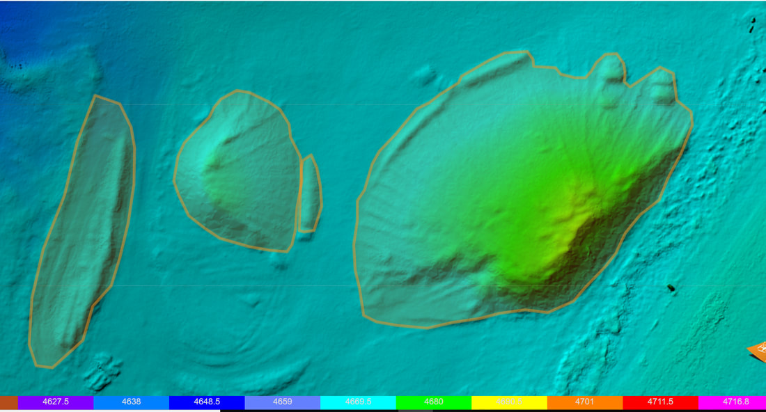
  • Soil Stock Pile Volume Calculations​​​
  • Cut Volume Calculations
  • Assessments of Large Tracts of Lands Such as Farms
  • Mining Reclamation and Remote Inspections of Claim Stakes
  • Easements and Right of Ways (ROWs)
  • Solar Array System Inspection
  • Tower and Building Inspections 
  • Water and Geologic Resources
  • Remote hard-to-reach areas
  • Wetland Resources
  • Security Issues
  • Wellhead Assessments 
  • Adjoining Commercial Property Liabilities
  • Pipelines
  • Power Lines 
  • Utilities 
  • Oil and Gas Field Surveys
  • Parking Lot and Asphalt Inspections
  • Roof Inspections 
  • Insurance Inspectionss
  • Ground measurements
  • Cellular Tower Inspections
  • Water Tower Inspections

Other uses include railroad derailments, search and rescue, updated imagery of phased-in developments, construction projects, and safety issues. 

We can also shoot 4K videos of any of your projects or property listings including 360 degree views.

Hess Environmental can provide classroom instruction on drone operations. 

Successful FAA Waivers 


Picture


​Updated aerial image of excavation trenches, oblique angle.  New trenches under construction to the west or left side of photograph. 


Picture


​Construction project management. 

Picture


Preliminary tower inspection 


Picture


​Solar panel inspection 


Picture


​Vandalism.  Three (3) of the solar panels painted.  Note that the cooling unit was painted as well. 

​

Picture


​WEDDINGS


Web Hosting by iPage
  • About Us
  • Underground Storage Tanks (UST), Phase II Phase 2, remediation Etc...
  • E1527-2021: Phase I Environmental Assessments and the New Standard
  • Ground Water
  • Law Firms
  • Large Ranches and Farms
  • Municipalities, Cities and Towns
  • News, Updates, Utah UST Deadlines
  • Demolitions
  • Drone Aerial Photography and Mapping
  • Soil Testing; Well Testing; Water Testing
  • Utah Earthquake, USTs and Drone Inspections
  • Aboveground Petroleum Storage Tanks (APST)
  • Household and Farm Hazardous Wastes
  • NEPA - USDA RD Rural Development
  • RCRA, SUPERFUND and RISK Based Closures
  • Contact Us
  • PAYMENTS